- You are here:
- Home

- Funded Projects
This research, funded by United States Department of Transportation (USDOT) Office of the Assistant Secretary for Research & Technology (OST-R) Commercial Remote Sensing and Spatial Information Technologies Program (CRS&SI), is developing an operational prototype for the rapid detection of fine scale damage to transportation infrastructure following natural hazard events. Lead by Dr. Chris Lippitt of UNM Geography and Environmental Studies, the project team includes the University of New Mexico (Co-PI Dr. Susan Bogus-Halter of Civil Engineering), San Diego State University (institutional-PI Dr. Douglas Stow) and BAE Systems Inc, makers of the Socet GXP® line of image exploitation software. The project team is building on previous research and patent pending technology to design a complete remote sensing system catered to the needs of New Mexico DOT (NMDOT) and USDOT’s infrastructure assessment needs. Approaches developed through the project will be incorporated into the Socet GXP® line of desktop, server, and mobile applications for image exploitation and will be demonstrated in Albuquerque, NM. Ultimately, the project seeks to make available the latest in precision change detection and user optimized remote sensing systems to USDOT for operational assessment of damage to transportation infrastructure following hazard events.
This project is supported by the National Science Foundation Award # CMMI-1360041
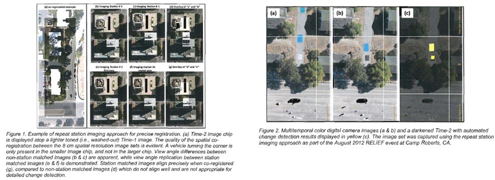
Researchers at San Diego State University (PI Dr. Douglas Stow) and the University of New Mexico (Institutional PI Dr. Chris Lippitt) will collaborate on research pertaining to important elements of end-to-end time-sensitive remote sensing systems (TSRSS) that support post-disaster assessment of damage to critical infrastructure and allocation of emergency response resources. This research aims to ascertain timeliness and reliability requirements for post-damage assessment of infrastructure deemed to be critical by emergency managers. Both simulation and empirical evaluation procedures will be employed to optimize the design and configuration of TSRSS. Further, theoretical approaches and design paradigms for the optimization will be used to design TSRSS to meet the needs of emergency managers. The repeat-station imaging approach to image-based damage detection, as well as technologies for aircraft-to-analyst and analyst-to-user transfer of data and information will be optimized, tested and demonstrated, in a manner that meets manager’s timeliness and reliability requirements.
This project is funded by the Research Allocation Committee at the University of New Mexico.
In the aftermath of a natural disaster, it is critical to evaluate the condition of infrastructure systems so that first responders can have access to the affected areas and officials can identify potential safety hazards. The need for maintenance of infrastructure similarly requires the routine monitoring of infrastructure status. Traditional assessment practices deploy engineers to perform on-site evaluations or airplane observations to evaluate areas that are inaccessible. These approaches have limitations in terms of lack of detail for the airplane-based observations and lack of accessibility for on-site observations, not to mention the cost of deploying observers to vast road networks. We therefor evaluate the use of unmanned remote sensing systems (URSS), which can fly lower to the ground than traditional airplanes, and thus, allow for detailed data to be collected without specially-designed, cost prohibitive sensors. Using roadway pavement assets as an example, this research explored the utility of hyper-spatial resolution (3-millimeter) multispectral digital aerial photography acquired from a low-altitude and low-cost URSS, in this case, a tethered helium weather balloon, to permit characterization of detailed pavement surface distress conditions.
Read more: Infrastructure Condition Assessment Using Low-cost Remote Sensing Techniques